Nan and the team have put together the below (epic!) video capturing many of the highlights of our 2014 tagging research. Enjoy!
Tuesday, 14 October 2014
Migration Update #5
I don't know about you, but I sure couldn't row a boat that straight for that long in the open ocean. Check out the map!
More in depth analysis to come - as soon as I finish teaching for the year this week.
All the best and thanks for still following along!
Travis
 |
| 121195.14 is our big mover of the week! 500+ km along a bearing that is straight as... That's roughly the meridional width of Wyoming or Colorado, and I bet this whale is swimming straighter than most folks drive on I-70. |
All the best and thanks for still following along!
Travis
Tuesday, 7 October 2014
Migration Update #4
Has the migration finally begun?
It seems most of our tagged whales are perfectly happy continuing to bounce between the islands of Oceania. 112716.14 continues to hang out around the small islands of northern Tonga, 112697.14 has joined the party in Samoa, and 87777.14 has shifted over to Atiu from Aitutaki in the southern Cook Islands.
121195.14 is the whale I have my eye on most at the moment. It has started swimming away from Samoa in an overall southeasterly direction. It could very well stop-over in Niue over the next few days - or it might very well keep on going all the way to the Antarctic. We'll have to wait and see if the southward migration has well and truly (finally!) begun, or if this is just another (truly remarkable!) example of island hopping...
I've updated the cumulative distance graphic as well (see below), in addition to the satellite transmission pie charts (further below). The cumulative distance plot continues to show that the open-water movements are faster than the near-shore movements - eventually I will do a piecewise linear regression breakpoint analysis on these distance versus time plots to objectively identify changes in the behavioural states of the whale movements (free from all the problems of state-space modeling and other forms of interpolation!). Meanwhile, the satellite transmission pie charts haven't changed very much (despite there being three times as many total transmissions received since my last update). This indicates to me that the current pattern of transmission quality/distribution should continue as long the whales stay in this sector of the South Pacific Ocean. As the whales start moving out of Oceania, however, the satellite transmission window gets broader and we might very well see an increase in the quality/number/distribution of the transmissions received. Maybe next week...
And speaking of Papi (what the Grandkids call my Dad - who is also named Travis), I have changed the 'inferred' path taken by 87777.14 in the updated map at the top of this post. I agree, Papi. There's no evidence to suggest 87777.14 took such a tortuous (i.e. sinuous) course during the period that it's transmitter tag went silent. All the other data would suggest that something more like the inferred (yellow dashed) path shown in the map above is more likely (than what I had previously inferred). That said, we'll never be able to prove it one way or another...
I'm gonna getcha. Gonna getcha, getcha, getcha, getcha, next week. Or another. Gonna find ya...
It seems most of our tagged whales are perfectly happy continuing to bounce between the islands of Oceania. 112716.14 continues to hang out around the small islands of northern Tonga, 112697.14 has joined the party in Samoa, and 87777.14 has shifted over to Atiu from Aitutaki in the southern Cook Islands.
121195.14 is the whale I have my eye on most at the moment. It has started swimming away from Samoa in an overall southeasterly direction. It could very well stop-over in Niue over the next few days - or it might very well keep on going all the way to the Antarctic. We'll have to wait and see if the southward migration has well and truly (finally!) begun, or if this is just another (truly remarkable!) example of island hopping...
 |
| Oct. 7, 2014 Humpback Whale Track Map |
I've updated the cumulative distance graphic as well (see below), in addition to the satellite transmission pie charts (further below). The cumulative distance plot continues to show that the open-water movements are faster than the near-shore movements - eventually I will do a piecewise linear regression breakpoint analysis on these distance versus time plots to objectively identify changes in the behavioural states of the whale movements (free from all the problems of state-space modeling and other forms of interpolation!). Meanwhile, the satellite transmission pie charts haven't changed very much (despite there being three times as many total transmissions received since my last update). This indicates to me that the current pattern of transmission quality/distribution should continue as long the whales stay in this sector of the South Pacific Ocean. As the whales start moving out of Oceania, however, the satellite transmission window gets broader and we might very well see an increase in the quality/number/distribution of the transmissions received. Maybe next week...
 |
| Cumulative Distance traveled versus time plot. Steeper slopes equate with faster open-water movements, lower slopes equate with slower near-shore movements. |
 |
| An update to the Argos satellite transmission distributions and location data quality (for those techno-gearheads out there; Hi, Dad!) |
I'm gonna getcha. Gonna getcha, getcha, getcha, getcha, next week. Or another. Gonna find ya...
Monday, 29 September 2014
Migration Update #3
We have passed the one-month mark since deployment of our first tag and what a month it has been!
One month ago we did not know how 'easily' humpback whales commute between the islands of Oceania. ['commuting' is a type of animal movement behavior distinct from migration, homing, dispersing, etc.]
One month ago we did not know that the migratory corridor between Rarotonga and American Samoa was so popular. [112697.14 and 120946.14 are swimming the route as at least a pair as I type!]
One month ago we did not know that humpback whales would swim more than 2000km across the tropics - roughly one-half the distance to the closest feeding grounds - only to come back to the same place they were at three weeks earlier! [this makes little sense considering the lack of food in tropical waters]
Meanwhile, Nan and the team SOMEHOW have recovered tag #87625 - the one that got deflected by a wave just as it was about to deploy! Last I heard, it was sitting on 46 meters down just outside Avana Harbour, when all of a sudden - PING! - a location shows up on my Argos satellite map. Unreal.
I've been doing all I can to educate and raise awareness regarding Oceania's endangered humpback whales (when not checking Argos or teaching here at U.Canterbury). The kind folks at the U.S. Embassy in Wellington, New Zealand even invited me to give them an interview on our research. Thanks much Jamiela, Michael, Laura, Ola, Tracey, Rob, Candy and all the good people at the embassy! You can link to the interview below (it's 20 minutes long - what can I say...I'm excited!).
One month ago we did not know how 'easily' humpback whales commute between the islands of Oceania. ['commuting' is a type of animal movement behavior distinct from migration, homing, dispersing, etc.]
One month ago we did not know that the migratory corridor between Rarotonga and American Samoa was so popular. [112697.14 and 120946.14 are swimming the route as at least a pair as I type!]
One month ago we did not know that humpback whales would swim more than 2000km across the tropics - roughly one-half the distance to the closest feeding grounds - only to come back to the same place they were at three weeks earlier! [this makes little sense considering the lack of food in tropical waters]
 |
| Rarotonga Humpback Whale Satellite Track Map - Sept. 29, 2014 |
Meanwhile, Nan and the team SOMEHOW have recovered tag #87625 - the one that got deflected by a wave just as it was about to deploy! Last I heard, it was sitting on 46 meters down just outside Avana Harbour, when all of a sudden - PING! - a location shows up on my Argos satellite map. Unreal.
I've been doing all I can to educate and raise awareness regarding Oceania's endangered humpback whales (when not checking Argos or teaching here at U.Canterbury). The kind folks at the U.S. Embassy in Wellington, New Zealand even invited me to give them an interview on our research. Thanks much Jamiela, Michael, Laura, Ola, Tracey, Rob, Candy and all the good people at the embassy! You can link to the interview below (it's 20 minutes long - what can I say...I'm excited!).
Tuesday, 23 September 2014
Migration Update #2
Another week, another 1000 km...
It's been an exciting 7 days since my last Megaptera14 humpback whale migration update! One transmitter tag has come back to life, one whale has been content cruisin' around Raro, and 4 others have made haste to new island homes. The data never cease to amaze me!
Tag #87777.14 just started transmitting locations again after a two-week hiatus. Last we heard from 87777.14, "he" was headed north away from Rarotonga. Approximately 21 hours ago, 87777.14 started sending transmissions again and it's looking like he misses Nan and the team - he's heading back towards Raro from ~700km due west of the island!
Since transmissions stopped on Sept. 8, 2014, it's anyone's guess what 87777.14 got up to. I have sketched in an ~1735 km long circuit route on the above map in yellow dashes. At an average traveling velocity of 5 km/hr over the 347 hour-long gap in transmissions, 87777.14 would have swam 1735 kilometers - the same distance as the yellow-dash circuit route.
However, if I had to bet on where 87777.14 actually went, my money would be on Manu'a (American Samoa). It's highly unlikely that it swam any faster than 6 km/hr for any extended period of time (this based on both the 2007 and 2014 swimming speeds observed for other humpbacks in the region). That would make 87777.14's maximum total distance traveled ~2100 km for the period between Sept. 8 and Sept. 23, 2014. It could have made it all the way to Upolu, but it wouldn't have had any time hang-out once it arrived there. The only other islands it could have reached, and had time to cruise, are Palmerston and Niue. Where do you think 87777.14 went?
Most of the other whales seem content hanging/cruising around new island homes. 112726.14 has spent time around both Niue and Vava'u (but it's now heading south-southwest parallel to the Tonga Trench!). 121195.14 has been around Manu'a for a few days now, and 81126.14 has stayed true to the Cooks and has been cruising around Atiu way for several days. 112697.14 is our home-body - it's still around Raro, and 120947.14 is my favorite because it followed the same ~550 km long 'straight as' track as 2007 tag #37282.07 (highlighted by the red ellipse in the above map).
It's absolutely exhilarating logging in to the Argos system and down-loading these data every day! These tracks are revealing several new and exciting things about humpback whale movement behavior and I do hope they keep on transmitting for many days to come. Stay tuned...
It's been an exciting 7 days since my last Megaptera14 humpback whale migration update! One transmitter tag has come back to life, one whale has been content cruisin' around Raro, and 4 others have made haste to new island homes. The data never cease to amaze me!
Tag #87777.14 just started transmitting locations again after a two-week hiatus. Last we heard from 87777.14, "he" was headed north away from Rarotonga. Approximately 21 hours ago, 87777.14 started sending transmissions again and it's looking like he misses Nan and the team - he's heading back towards Raro from ~700km due west of the island!
 |
| 23 Sept, 2014 update of humpback whale movements. |
Since transmissions stopped on Sept. 8, 2014, it's anyone's guess what 87777.14 got up to. I have sketched in an ~1735 km long circuit route on the above map in yellow dashes. At an average traveling velocity of 5 km/hr over the 347 hour-long gap in transmissions, 87777.14 would have swam 1735 kilometers - the same distance as the yellow-dash circuit route.
However, if I had to bet on where 87777.14 actually went, my money would be on Manu'a (American Samoa). It's highly unlikely that it swam any faster than 6 km/hr for any extended period of time (this based on both the 2007 and 2014 swimming speeds observed for other humpbacks in the region). That would make 87777.14's maximum total distance traveled ~2100 km for the period between Sept. 8 and Sept. 23, 2014. It could have made it all the way to Upolu, but it wouldn't have had any time hang-out once it arrived there. The only other islands it could have reached, and had time to cruise, are Palmerston and Niue. Where do you think 87777.14 went?
Most of the other whales seem content hanging/cruising around new island homes. 112726.14 has spent time around both Niue and Vava'u (but it's now heading south-southwest parallel to the Tonga Trench!). 121195.14 has been around Manu'a for a few days now, and 81126.14 has stayed true to the Cooks and has been cruising around Atiu way for several days. 112697.14 is our home-body - it's still around Raro, and 120947.14 is my favorite because it followed the same ~550 km long 'straight as' track as 2007 tag #37282.07 (highlighted by the red ellipse in the above map).
It's absolutely exhilarating logging in to the Argos system and down-loading these data every day! These tracks are revealing several new and exciting things about humpback whale movement behavior and I do hope they keep on transmitting for many days to come. Stay tuned...
Thursday, 18 September 2014
For Your Viewing Pleasure...
...I've prepared some YouTube clips. These are not just regular old home movies, folks. These are truly spectacular images that capture some magical moments. Enjoy!
I'll post an update on the whale movements in a few days. Thanks for following along!
Travis
Travis
Monday, 15 September 2014
Migration Update #1
One week and one-thousand kilometers later, three of our tagged whales are heading west...
Now that I am back in Christchurch, my updates to Megaptera14 are going to be about once a week. Monday nights (NZ time) work best. But I do promise to keep updating you all so long as these tags are transmitting!
For this week's update, I've prepared some graphics. Top of the order is an update on where our whales have headed (this will be the standard lead-off position in the weeks ahead as well - Figure 1 is almost always a map when you're dealing with a ball-playing geoscientist!). There are several interesting points to make about the whale movement data presented in Figure 1 (below).
First, the migrating whales are moving west/northwest along very similar paths. This 'route fidelity' is fascinating to me as none of these whales are ever in the same place at the same time. They might very well pass over the same chunk of ocean floor (~5000m below them!), but they're doing so at different times (n.b. - the tracks symbolized by triangles are from 2007! The larger colored circles are the 2014 data.). If there is an outbound migration corridor around Rarotonga, it is most certainly to the west-northwest. This gives us strong evidence to suggest potential 'no-long-line-fishing' zones during certain months of the year - a triangle connecting Rarotonga, Niue, and Palmerston would be a great start!
Second, our 2014 data is much higher temporal resolution than our 2007 data. In other words, we are receiving more transmissions per day from each tag in 2014 than we did from each tag in 2007. This is GREAT PROGRESS as the temporal resolution of the data dramatically impacts the level to which we can interpret each whale's movement behaviors! More data points means we have a greater chance of capturing turns, slow-downs, speed-ups, etc. I am very excited by the temporal quality of our data this year. Here's hoping the tags keep transmitting for several months!!
Third, I might be seeing things, but it sure looks like 112726.14 got a call from Niue yesterday and decided to stop in for a visit. 'She' should arrive in Niue late on Sept. 15 local time if she keeps following the same trajectory. Now you might think I'm really starting to see things if you believe me when I say that it looks like one of the 2007 whales did a very similar thing just before its tag dropped (medium grey triangles approaching Niue from the east-southeast). Maybe polynesians really did 'ride whales' when they were island hopping during the past millennium?
Fourth, the Distance Traveled versus Day of Year plot shows that this year's migrators are a fast bunch. They've been swimming ~6-7 km/hr for the past week straight without stopping - day or night. Cool.
For those of you who love data (like me), I've made a couple extra plots for your viewing pleasure and metacognitive pain. Figure 2 presents a couple pie charts. The one on the left shows the relative proportions of location data received by the 6 different Argos system satellites (MA, MB, NK, NN, NP, SR). The pie chart on the right shows the relative distribution of the location data's quality (3 is the best quality, zero is the worst quality - A and B could be good or could be bad, the Argos system couldn't tell). Clearly we're getting mostly 'B' quality data. This is not ideal, but it's not necessarily bad either...
Figure 3 shows all of the whale locations the Argos system has received as a function of hour of the day. The vertical axis is plotting the 'error radius' of the whale location as determined by the Argos system (all those 'B' quality locations have largely 1-5 km errors - which is not so bad considering the spatial scale of the migrations). The parabolic curves are plotting when each of the Argos system satellites are able to receive radio transmissions (i.e. the vertical axis for the parabolic curves is basically how high in the sky the satellite is during its passage over the region). I can't see any clear pattern relating satellite position, or satellite count, to error radius. And it looks like our chosen transmission periods don't have many holes/gaps; we deliberately pre-programmed the transmitters to save battery and shut-down when the 'NP' satellite was passing as it was the sole satellite during its passages over Oceania this time of the year.
Perhaps the BEST thing about Figure 3 is that it shows quite clearly that we're capturing both sides of dawn and dusk nicely. Crepuscular (homework = look it up!) behaviors are common in the biosphere and I quite deliberately made sure that we set up the tags to collect data across these important times of the day. I'd estimate that half our data was collected during periods of darkness and half our data was collected during periods of daylight. The possibilities indeed are endless.
And I'm curious as to whether or not last week's class 2 solar flare wrought any havoc on the navigational systems used by these whales. Another topic for another day, perhaps?
Now that I am back in Christchurch, my updates to Megaptera14 are going to be about once a week. Monday nights (NZ time) work best. But I do promise to keep updating you all so long as these tags are transmitting!
For this week's update, I've prepared some graphics. Top of the order is an update on where our whales have headed (this will be the standard lead-off position in the weeks ahead as well - Figure 1 is almost always a map when you're dealing with a ball-playing geoscientist!). There are several interesting points to make about the whale movement data presented in Figure 1 (below).
First, the migrating whales are moving west/northwest along very similar paths. This 'route fidelity' is fascinating to me as none of these whales are ever in the same place at the same time. They might very well pass over the same chunk of ocean floor (~5000m below them!), but they're doing so at different times (n.b. - the tracks symbolized by triangles are from 2007! The larger colored circles are the 2014 data.). If there is an outbound migration corridor around Rarotonga, it is most certainly to the west-northwest. This gives us strong evidence to suggest potential 'no-long-line-fishing' zones during certain months of the year - a triangle connecting Rarotonga, Niue, and Palmerston would be a great start!
 |
Figure 1 - Humpback Whale movements near Rarotonga (mid September, 2014) |
Second, our 2014 data is much higher temporal resolution than our 2007 data. In other words, we are receiving more transmissions per day from each tag in 2014 than we did from each tag in 2007. This is GREAT PROGRESS as the temporal resolution of the data dramatically impacts the level to which we can interpret each whale's movement behaviors! More data points means we have a greater chance of capturing turns, slow-downs, speed-ups, etc. I am very excited by the temporal quality of our data this year. Here's hoping the tags keep transmitting for several months!!
Third, I might be seeing things, but it sure looks like 112726.14 got a call from Niue yesterday and decided to stop in for a visit. 'She' should arrive in Niue late on Sept. 15 local time if she keeps following the same trajectory. Now you might think I'm really starting to see things if you believe me when I say that it looks like one of the 2007 whales did a very similar thing just before its tag dropped (medium grey triangles approaching Niue from the east-southeast). Maybe polynesians really did 'ride whales' when they were island hopping during the past millennium?
Fourth, the Distance Traveled versus Day of Year plot shows that this year's migrators are a fast bunch. They've been swimming ~6-7 km/hr for the past week straight without stopping - day or night. Cool.
For those of you who love data (like me), I've made a couple extra plots for your viewing pleasure and metacognitive pain. Figure 2 presents a couple pie charts. The one on the left shows the relative proportions of location data received by the 6 different Argos system satellites (MA, MB, NK, NN, NP, SR). The pie chart on the right shows the relative distribution of the location data's quality (3 is the best quality, zero is the worst quality - A and B could be good or could be bad, the Argos system couldn't tell). Clearly we're getting mostly 'B' quality data. This is not ideal, but it's not necessarily bad either...
 |
Figure 2 - early to middle September (2014) Rarotonga humpback whale satellite transmission data - by Argos satellite (left) and data quality (right) |
Figure 3 shows all of the whale locations the Argos system has received as a function of hour of the day. The vertical axis is plotting the 'error radius' of the whale location as determined by the Argos system (all those 'B' quality locations have largely 1-5 km errors - which is not so bad considering the spatial scale of the migrations). The parabolic curves are plotting when each of the Argos system satellites are able to receive radio transmissions (i.e. the vertical axis for the parabolic curves is basically how high in the sky the satellite is during its passage over the region). I can't see any clear pattern relating satellite position, or satellite count, to error radius. And it looks like our chosen transmission periods don't have many holes/gaps; we deliberately pre-programmed the transmitters to save battery and shut-down when the 'NP' satellite was passing as it was the sole satellite during its passages over Oceania this time of the year.
 |
| Figure 3 - Relationship between satellite transmission data quality (as Argos error radius), time of day, and receiving satellite position. |
Perhaps the BEST thing about Figure 3 is that it shows quite clearly that we're capturing both sides of dawn and dusk nicely. Crepuscular (homework = look it up!) behaviors are common in the biosphere and I quite deliberately made sure that we set up the tags to collect data across these important times of the day. I'd estimate that half our data was collected during periods of darkness and half our data was collected during periods of daylight. The possibilities indeed are endless.
And I'm curious as to whether or not last week's class 2 solar flare wrought any havoc on the navigational systems used by these whales. Another topic for another day, perhaps?
Monday, 8 September 2014
Tag count 1!
Huge progress over the past few days! The team's hard work has really paid off with four more tags successfully deployed over the past 48 hours. That brings our total to 9 tags deployed - with 8 of them having transmitted humpback whale locations to us via the Argos satellite system. Great work TEAM!
Our track data are already revealing several interesting results. One of the whales (tag 87777.14) has already started migrating away from Rarotonga...to the NORTH! This is a brand new insight into Rarotonga humpback movement behavior given that all seven of the 2007 whales headed away from Raro in a west to northwest direction (see map below). In fact, 87777.14 is charting an entirely new course - and a bewildering one at that - as we'd expect these whales to start moving SOUTH in Spring, not north.
Another interesting early result is the movement velocity of these whales. My preliminary analysis suggests these whales migrate at speeds around 5 km/hr, based on both the 2007 and 2014 migratory movement velocities (see below graphic). However, when they are hanging around Rarotonga, the data indicate that the whales swim at slower speeds, closer to 2 km/hr. This is an interesting result as it can help us follow whales around the island and anticipate where they will next come to the surface for a breath. These results also provide a possible means of differentiating migratory behaviors from non-migratory behaviors. Cool!
But that's not all we've been discovering! Our longest track so far is for a whale that hasn't even left Raro yet (and who can blame it?). What's neat about this one's track is that we can study it to better understand the movement behaviors in the waters around the island. It seems this whale (81126.14) might be a reincarnated albatross - it seems perfectly content circumnavigating the island every few days! By studying this whale's movements in unprecedented detail we can start exploring patterns in its behavior: go clockwise if...; turn around when...; stay put in response to...etc. We've never had data of this spatial and temporal quality before so even these 'local' movements are tremendously exciting!
And for those of you thinking about taking a trip to Rarotonga some day, be sure to stock up on your Hawaiian shirts and dresses while on the island! It's become a tradition in our family!
More to come in the week's ahead folks! Stay tuned....
Our track data are already revealing several interesting results. One of the whales (tag 87777.14) has already started migrating away from Rarotonga...to the NORTH! This is a brand new insight into Rarotonga humpback movement behavior given that all seven of the 2007 whales headed away from Raro in a west to northwest direction (see map below). In fact, 87777.14 is charting an entirely new course - and a bewildering one at that - as we'd expect these whales to start moving SOUTH in Spring, not north.
 |
| Preliminary map of 2014 and 2007 humpback whale satellite track data. One of the 2014 tagged whales has already left Rarotonga, heading north! (yellow circles, 87777.14) |
Another interesting early result is the movement velocity of these whales. My preliminary analysis suggests these whales migrate at speeds around 5 km/hr, based on both the 2007 and 2014 migratory movement velocities (see below graphic). However, when they are hanging around Rarotonga, the data indicate that the whales swim at slower speeds, closer to 2 km/hr. This is an interesting result as it can help us follow whales around the island and anticipate where they will next come to the surface for a breath. These results also provide a possible means of differentiating migratory behaviors from non-migratory behaviors. Cool!
 |
| Preliminary distance versus time plot for the class of '14. Constant slopes on this plot represent constant swimming speeds (i.e. movement velocities). All of the migrating 2007 whales maintained swimming speeds of ~5 km/hr, just like 87777.14 has done over the past few days (non-stop mind you!). |
But that's not all we've been discovering! Our longest track so far is for a whale that hasn't even left Raro yet (and who can blame it?). What's neat about this one's track is that we can study it to better understand the movement behaviors in the waters around the island. It seems this whale (81126.14) might be a reincarnated albatross - it seems perfectly content circumnavigating the island every few days! By studying this whale's movements in unprecedented detail we can start exploring patterns in its behavior: go clockwise if...; turn around when...; stay put in response to...etc. We've never had data of this spatial and temporal quality before so even these 'local' movements are tremendously exciting!
 |
| 81126.14 circumnavigates Rarotonga! This loop took 2.5 days at a relatively constant swimming speed of 2 km/hr. It did play pinball off Fruits of Rarotonga on the 248th day of the yea - so it could make a full circuit in about 1 day of non-stop swimming at this cruising speed. |
And for those of you thinking about taking a trip to Rarotonga some day, be sure to stock up on your Hawaiian shirts and dresses while on the island! It's become a tradition in our family!
 |
| Zach, Katie, and Maddy model this year's line. |
Thursday, 4 September 2014
Tag Count 5
We're down to 5 tags remaining! Our patience and persistence has paid off. After a day on-land watching for whales from shore due to extreme seas, we were back on the water again yesterday. Despite being restricted to the western side of the island due to strong easterly winds continuing to stir things up, we were able to deploy three tags. Unfortunately the first tag got deflected by a white cap just as it contacted the whale and did not deploy. That tag is now at the bottom of the sea in 46m of water, and we followed the whale for over an hour to see if its behavior changed (it didn't).
The other two deployments yesterday were as close to perfect as you can ask for! Nan did an exceptional job captaining the boat and Federico placed the tags with extreme accuracy. Alex just passed on that one of these whales has already moved off-shore and is headed towards Samoa! The second whale we tagged yesterday continues to swim around Rarotonga - and based on what we saw yesterday, this one likes to swim on its back!

 |
| Natalie, Alex and Federico look for whales along the west coast of Rarotonga on Tuesday Sept. 2, 2014. The lagoon (inside the reef) is calm, but the seas beyond were too choppy to tag. |
The other two deployments yesterday were as close to perfect as you can ask for! Nan did an exceptional job captaining the boat and Federico placed the tags with extreme accuracy. Alex just passed on that one of these whales has already moved off-shore and is headed towards Samoa! The second whale we tagged yesterday continues to swim around Rarotonga - and based on what we saw yesterday, this one likes to swim on its back!
Monday, 1 September 2014
Still on 8
Well, the ocean has not been that cooperative the past two days. We're being extremely patient and persistent, getting on the water early, following individual whales for hours on end, putting ourselves in a position to deploy tags, but the combination of a strong southerly swell and 17 knot winds out of the east have stirred up some decent chop. The choppiness of the sea has prevented us from being able to attempt any more tag deployments the past two days - we still have 8 tags in hand.
Despite the high (and low) seas, we have been seeing whales. Not nearly the density found in other calving/breeding areas such as Abrolhos Bank, Brazil, but there are definitely multiple whales in the area.
When we have not been on the water, the team has kept extremely busy with maintaining the gear, downloading the daily datasets: photos, voice logs, whale song recordings, skin samples, waypoints of whale surface activity, among other things. A question for all the the blog followers at Ilam School (Christchurch, New Zealand) and elsewhere: What do you think we use each of these datasets for? I'm more than happy to come in to school upon my return to ChCh and learn what you come up with!
My evenings have been spent analyzing the daily whale location data and teaching the team how and why I do these analyses. I'll post a mini-lesson to the blog in the days ahead - but here's a little tidbit for y'all...
We already have one very interesting humpback track result: the first whale we tagged went on a >100 km excursion to the north of Rarotonga. The whale swam ~40km north, turned to the west at some stage, and then returned to Raro following a highly directional (i.e. straight line) path. Let's put this movement in some context. Humpbacks travel at ~5km/hour in open ocean. Thus, this 'little' excursion took at least 16 hours to complete. While we were searching for whales, washing down gear, downloading data, and sleeping, this whale was performing a remarkable feat of site fidelity. It left Rarotonga only to come straight back again. One way or another, it clearly knows where it is; my job is to try to figure how.
Last night I had the extreme pleasure of teaching. I love to teach - this is the main reason why I'm in academia. Last night's learning centered on the various theories of how animals navigate and took a closer look at Earth's magnetic field - one of the possible sources of spatial information available to migratory animals. We welcomed close friends from Muri Beach Club Hotel and Abigail's Mom, Felicity, along for the session. I hope it was an engaging learning experience!
Erica, from Muri Beach Club Hotel, passed on some awesome information last night about upcoming events down in Muri related to building and reinforcing the support for Nan's humpback whale research. It's just awesome having supporters and advocates in the community and the folks at MBCH have been leading the way! Thank you so very much, Erica!
So we're off to the marina, hoping for flatter water! All we can do is be patient, persistent, and wise in our decision-making regarding when to attempt a tag deployment. The safety of the whales and the tagging team are our highest priorities. Although it may very well be a journey of ups and downs, its most importantly a journey that is moving forward.
- Travis Horton
Saturday, 30 August 2014
Tag Count 8
Another day on the water - another tag successfully deployed!
It was markedly windier on the water today - which meant even larger swells and more wind shear on the water's surface. White caps everywhere even on the lee-side of the island particularly in the morning. We again focussed our efforts in the calmer waters just offshore of Avarua, the main township on Rarotonga.
The local fishermen have been instrumental in providing us accurate and timely information regarding whale locations, sighting times, and direction of movement. Our successes are largely a result of the excellent and collaborative nature of the relationship Nan has established with the fishermen over the past 17 years. Thank you all so very much and particularly to Akura Fishing!
Perhaps the best news of the day came when we got back to Nan's house tonight - Alex checked the Argos satellite system and BOTH TAGS ARE TRANSMITTING WHALE LOCATIONS!
I am particularly thrilled by this news as it means everything is fundamentally working. We're getting the job done and we will have new movement/migration data from the Rarotonga humpback whale population to compare to previous years (2006-2007). I spent the after dinner hours modeling Earth's Main magnetic field, as well as its rock anomaly field, in the area immediately surrounding Rarotonga itself. By taking a closer look at the whales' movements in the waters around the island itself, rather than in open ocean far away from any coastlines, I hope to assess whether or not there are any systematic patterns in the whale movements in magnetic coordinate space(s). We'll also look at the geographic coordinates as well of course!
While I was running computer models on my computer (thank you Stefan Maus!), Federico was busy prepping another tag. Hopefully we'll hit the water early in the AM tomorrow with the forecasted lower winds and three more tags ready to be deployed. It's hard to pass on the excitement and enthusiasm we all have been carrying these past several days. We are making moments that we will all cherish for many years to come and every minute of my time here in Raro has been beyond enjoyable. It's a tremendous honor to be able to share these moments with you!
More to come tomorrow on the whale locations provided by Argos and some of the things I've learned about whale movement behavior in Rarotonga! Oh, and wouldn't it be swell if we deployed another tag or two. Here's hoping!
- Travis Horton
It was markedly windier on the water today - which meant even larger swells and more wind shear on the water's surface. White caps everywhere even on the lee-side of the island particularly in the morning. We again focussed our efforts in the calmer waters just offshore of Avarua, the main township on Rarotonga.
The local fishermen have been instrumental in providing us accurate and timely information regarding whale locations, sighting times, and direction of movement. Our successes are largely a result of the excellent and collaborative nature of the relationship Nan has established with the fishermen over the past 17 years. Thank you all so very much and particularly to Akura Fishing!
Perhaps the best news of the day came when we got back to Nan's house tonight - Alex checked the Argos satellite system and BOTH TAGS ARE TRANSMITTING WHALE LOCATIONS!
 |
| Federico gets in position for deployment of our second tag (August 29, 2014 - Rarotonga) |
I am particularly thrilled by this news as it means everything is fundamentally working. We're getting the job done and we will have new movement/migration data from the Rarotonga humpback whale population to compare to previous years (2006-2007). I spent the after dinner hours modeling Earth's Main magnetic field, as well as its rock anomaly field, in the area immediately surrounding Rarotonga itself. By taking a closer look at the whales' movements in the waters around the island itself, rather than in open ocean far away from any coastlines, I hope to assess whether or not there are any systematic patterns in the whale movements in magnetic coordinate space(s). We'll also look at the geographic coordinates as well of course!
While I was running computer models on my computer (thank you Stefan Maus!), Federico was busy prepping another tag. Hopefully we'll hit the water early in the AM tomorrow with the forecasted lower winds and three more tags ready to be deployed. It's hard to pass on the excitement and enthusiasm we all have been carrying these past several days. We are making moments that we will all cherish for many years to come and every minute of my time here in Raro has been beyond enjoyable. It's a tremendous honor to be able to share these moments with you!
More to come tomorrow on the whale locations provided by Argos and some of the things I've learned about whale movement behavior in Rarotonga! Oh, and wouldn't it be swell if we deployed another tag or two. Here's hoping!
- Travis Horton
Friday, 29 August 2014
Tag Count 9
We did it! We have successfully deployed our first satellite transmitter tag in Rarotonga, 2014!!
At 11:35AM on August 28, 2014 Federico had a clean shot and he took it. The tag was deployed in one of two sub-adults (roughly 5-7 years old by best guess) that we followed for close to an hour prior to deploying the tag. The tag was deployed on a whale with a fairly recognizable dorsal fin - see below (keep your eyes peeled for this one folks in Tonga, Samoa, and New Caledonia!). The tag was duty cycled to turn on at 5:00PM local time (3AM on August 29, UTC), so we are still waiting for the Argos system to return our first locations. I'll keep you posted!
We followed both whales for an hour following deployment (they stayed together both before and after the tag was deployed). No noticeable changes in either whale's behavior was observed. We thought to tag the second whale, but the second tag was in the support boat to ensure that it didn't get rained on (rain damages the degradable tape we use to hold back the tag's flanges). The tagging boat pulled alongside us at 12:40 and we decided to celebrate by eating lunch while also getting a debrief from the tagging team.
Overall it was another beautiful day on the water and we saw several humpback whales - hard to ask for more than what we got today. We are fairly confident that many of the whales we saw today were some of the same ones we saw yesterday - based on coloration, fluke shape/color pattern, dorsal fin shape, and behavior - but this requires scientific analysis of the data we've been collecting out in the boats. We've been taking heaps of photos, we now have two 20 minute recordings of humpback song(s), skin samples, one tagged deployed, and nine to go!
To give you an idea as to what some of the follow-up science involves, I've quickly put together the below fluke images. The image on the top is the dorsal surface of a whale's fluke and the image in the middle is a 'magnetic lasso' trace of the same fluke's edge. Although these top two images do not capture the ventral surface coloration pattern, the shape of the serrated edge of the fluke potentially be used to help confirm a re-sighting of this whale sometime in the future. The bottom image is of the ventral surface of a different whale's fluke - notice the difference in serration and the patterned colorations? These are some of the key features we use to ID whales.


One of the key steps in any scientific research process is to document what you've observed. The fluke and dorsal fin photos will be compiled in a database and ultimately made available to the wider humpback whale community for possible matching between different years and/or different places.
Here's hoping we have another successful day tomorrow and my fingers are crossed for some Argos location data in the morning!
Thanks for following along, folks. We're well and truly into the journey...
- Travis Horton
At 11:35AM on August 28, 2014 Federico had a clean shot and he took it. The tag was deployed in one of two sub-adults (roughly 5-7 years old by best guess) that we followed for close to an hour prior to deploying the tag. The tag was deployed on a whale with a fairly recognizable dorsal fin - see below (keep your eyes peeled for this one folks in Tonga, Samoa, and New Caledonia!). The tag was duty cycled to turn on at 5:00PM local time (3AM on August 29, UTC), so we are still waiting for the Argos system to return our first locations. I'll keep you posted!
 |
| Tag placement for our first Rarotonga satellite tag deployment in seven years. Note the distinct dorsal fin shape on this 5-7 year old sub-adult. (August 28, 2014) |
We followed both whales for an hour following deployment (they stayed together both before and after the tag was deployed). No noticeable changes in either whale's behavior was observed. We thought to tag the second whale, but the second tag was in the support boat to ensure that it didn't get rained on (rain damages the degradable tape we use to hold back the tag's flanges). The tagging boat pulled alongside us at 12:40 and we decided to celebrate by eating lunch while also getting a debrief from the tagging team.
Overall it was another beautiful day on the water and we saw several humpback whales - hard to ask for more than what we got today. We are fairly confident that many of the whales we saw today were some of the same ones we saw yesterday - based on coloration, fluke shape/color pattern, dorsal fin shape, and behavior - but this requires scientific analysis of the data we've been collecting out in the boats. We've been taking heaps of photos, we now have two 20 minute recordings of humpback song(s), skin samples, one tagged deployed, and nine to go!
 |
| A one to two week old humpback whale calf sun-bathing, belly-side up, just off the reef near Black Rock, Rarotonga. (August 28, 2014) |
To give you an idea as to what some of the follow-up science involves, I've quickly put together the below fluke images. The image on the top is the dorsal surface of a whale's fluke and the image in the middle is a 'magnetic lasso' trace of the same fluke's edge. Although these top two images do not capture the ventral surface coloration pattern, the shape of the serrated edge of the fluke potentially be used to help confirm a re-sighting of this whale sometime in the future. The bottom image is of the ventral surface of a different whale's fluke - notice the difference in serration and the patterned colorations? These are some of the key features we use to ID whales.
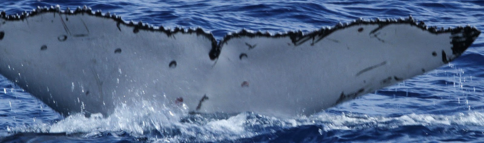 |
| Top - Dorsal (back) surface of one whale's fluke; Middle - A computer generated trace of the fluke above; Bottom - Ventral (bottom) surface of a different whale's fluke. |
One of the key steps in any scientific research process is to document what you've observed. The fluke and dorsal fin photos will be compiled in a database and ultimately made available to the wider humpback whale community for possible matching between different years and/or different places.
Here's hoping we have another successful day tomorrow and my fingers are crossed for some Argos location data in the morning!
Thanks for following along, folks. We're well and truly into the journey...
- Travis Horton
Thursday, 28 August 2014
Media Coverage
The Rarotonga 2014 Humpback Whale satellite tagging team is grateful to all the media exposure we've been getting over the past few days!
For those interested, here are some links:
Cook Islands News (newspaper)
Cook Islands Television (11 minute video)
60 Minutes (U.S.A. - replay on August 14, 2014 of Oct. 2013 interview with Nan Hauser)
NewsTalk ZB has a small piece on our research on-line and the U.S. Embassy in New Zealand has released a press release.
More information is always available (Thanks to the great work of Byron Brown, one Nan's core team members!) at www.nanhauser.com.
Off to the water! Happy Birthday Madeleine!! Daddy loves you so much kiddo!!
-Travis Horton
Tag Count 10
Another exciting day in Rarotonga - our first day on the water. Nan and her research team got the two boats - tagging boat and support boat - into the water in the AM and took the tagging boat for a test drive. Unfortunately it failed.
Nobody ever said this was going to be easy!
Some emergency repairs (bad fuel seems to be the culprit) were done in short order and both boats were out on the water by early afternoon. By this time the winds and swell had picked up a bit, so we focussed our search for taggable whales to the lee-side (the north side on this day). We didn't have to wait long to have first contact. Just a few minutes out of the harbor we spotted a mother and calf heading east and we picked up a couple juvenile males (most likely) heading west not long thereafter.
But seeing whales and tagging them successfully are two completely different things. Now let me come clean here - I'd never seen a humpback whale before yesterday and those 4 were seen from the beach for ~10 minutes. Today, I had the extreme fortune of seeing 7 humpbacks in our first hour on the water. I was part of the support boat team and we had the job of spotting, collecting sloughed skin following breaches and flukes for isotopic analysis, and documenting everything. Natalie did detailed documentations of everything we saw with a voice recorder, Alyssa was chief skin catcher and vocalisation recorder (we got a ~20 minute recording of a new song today!), Nan's daughter Ally drove the boat (masterfully!), and I was chief photographer (I have a lot to learn about filming wildlife at sea!). The highlight of my day was seeing a humpback slowly raise its back out of the water not 40 meters from our boat and exhale. The grace and fluidity of the movement was striking.
The tagging boat team consisted of Nan, Alex, Federico, and Abigail. Nan drove, Alex spotted and coordinated the movements, Federico was the wisened tagger, and Abigail was on GoPro (I can't wait to see their footage!). The tagging boat is one of the fastest and most maneuverable boats on Rarotonga. It needs to be. It is able to quickly catch up to a spotted whale and position the tagging team for an extended low speed observation period. Once within 100m the team assesses the whale's behavior, size and ultimate suitability for tagging. So although we saw several whales today - and a few of them were deemed taggable - we did not deploy any of our ten tags as no clear deployment shots were available. The last thing we want to do is improperly deploy a tag and expose either the whale or the team to increased risk of harm. Alex and Federico showed the wisdom of their combined experience tagging whales today by not acting on half-chances.
So we all now go to bed, dreaming of whales, but also smiling - knowing that tomorrow is another day with new and exciting adventures. If we are patient and we get a bit of good fortune we will tag our first whale of the season.
- Travis Horton
Nobody ever said this was going to be easy!
Some emergency repairs (bad fuel seems to be the culprit) were done in short order and both boats were out on the water by early afternoon. By this time the winds and swell had picked up a bit, so we focussed our search for taggable whales to the lee-side (the north side on this day). We didn't have to wait long to have first contact. Just a few minutes out of the harbor we spotted a mother and calf heading east and we picked up a couple juvenile males (most likely) heading west not long thereafter.
But seeing whales and tagging them successfully are two completely different things. Now let me come clean here - I'd never seen a humpback whale before yesterday and those 4 were seen from the beach for ~10 minutes. Today, I had the extreme fortune of seeing 7 humpbacks in our first hour on the water. I was part of the support boat team and we had the job of spotting, collecting sloughed skin following breaches and flukes for isotopic analysis, and documenting everything. Natalie did detailed documentations of everything we saw with a voice recorder, Alyssa was chief skin catcher and vocalisation recorder (we got a ~20 minute recording of a new song today!), Nan's daughter Ally drove the boat (masterfully!), and I was chief photographer (I have a lot to learn about filming wildlife at sea!). The highlight of my day was seeing a humpback slowly raise its back out of the water not 40 meters from our boat and exhale. The grace and fluidity of the movement was striking.
The tagging boat team consisted of Nan, Alex, Federico, and Abigail. Nan drove, Alex spotted and coordinated the movements, Federico was the wisened tagger, and Abigail was on GoPro (I can't wait to see their footage!). The tagging boat is one of the fastest and most maneuverable boats on Rarotonga. It needs to be. It is able to quickly catch up to a spotted whale and position the tagging team for an extended low speed observation period. Once within 100m the team assesses the whale's behavior, size and ultimate suitability for tagging. So although we saw several whales today - and a few of them were deemed taggable - we did not deploy any of our ten tags as no clear deployment shots were available. The last thing we want to do is improperly deploy a tag and expose either the whale or the team to increased risk of harm. Alex and Federico showed the wisdom of their combined experience tagging whales today by not acting on half-chances.
 |
| The sun sets on our first day on the water. |
So we all now go to bed, dreaming of whales, but also smiling - knowing that tomorrow is another day with new and exciting adventures. If we are patient and we get a bit of good fortune we will tag our first whale of the season.
- Travis Horton
Wednesday, 27 August 2014
Preparing the tags...
23:00 August 26, 2014
After a morning of interviews (NewstalkZB; Cook Islands News; Cook Islands TV) and a midday session sighting in of the scope on our pneumatic line thrower (that's how we'll be deploying the tags this year - see the video below!), the team spent the afternoon at the Cook Islands Whale and Wildlife Center. The Whale and Wildlife Center is one of my favorite places on Rarotonga - I learn something absolutely fascinating every time I go (today I learned that sea turtles slow their heart rates dramatically while diving to feed - this allows them to stay down longer). We were at the center so Nan could give a talk to a group of U.S. study abroad students (IES program) who are at the University of Canterbury this winter semester. Imagine my surprise to hop out of the back of Nan's Whale Research ute (that's the austral word for 'pick-up truck') only to see a couple of the students I was just teaching last week in lecture theaters at UC!
From the Whale and Wildlife Center, it was off to dinner with some of our new friends from the Wildlife Trust's Living Seas project. This was a very special evening - 4 humpbacks, a mother and calf with two male escorts were swimming past just outside the lagoon as we drove up. An awesome start to a fantastic dinner of fish burgers and chips (aka French fries). We were even lucky enough to get a private viewing of a Living Seas documentary on Grey Reef Shark feeding behavior in Coral Canyon, French Polynesia - Simply EPIC! Thanks, Phil!!
Back at HQ, Alex and Frederico got stuck into the task of sterilizing the satellite tags while I looked up the Argos satellite passage times in the South Pacific for the next few months. We need to program the tags to transmit to the satellites at specified times of the day in order to preserve battery life and maximize data quality/scientific outcomes. Thus, we want to program the tags such that they transmit when there are largest possible number of satellite connections available in the region. We achieve this by picking the times of the day when there are 2-3 satellites in transmission range. There are now only 6 Argos satellites remaining and their orbital periods are spread across the 24-hour day. Apparently all the Argos satellites are past their initial life expectancies, so there is significant motivation to get sat track data while the satellites are still operational!
These are crucially important aspects of tagging that I hadn't fully appreciated - this is the first time Alex and I have been together on a tagging trip despite our 7-year international collaborations together (the financial pressures on our research are not insignificant). Ultimately, Alex and I programmed 3 of the 10 tags for possible deployment tomorrow AM. We chose a daily 3 hours off - 8 hours on - 4 hours off - 7 hours on - 2 hours off duty cycle for these three tags. This will maximize the potential for gaining the highest quality data, while also capturing the dawn and dusk periods - natural time stamps that animals might use as part of their navigational decision-making process.
So we're off to tag in the AM all going well! I will send along an update as soon as I can...
Thanks for following along, folks!
-Travis
Tuesday, 26 August 2014
The Team!
 |
| The 2014 Rarotonga Humpback Whale Tagging Team! (from left to right: Hsuan; Abigail; John; Alyssa; Natalie; Frederico; Travis; Nan; Alex) |
It's been an amazing and eventful first half-day on Rarotonga! The team just finished interviews with Cook Islands television and the Cook Islands News (the local newspaper). Frederico and Alex are trialling the tag deployment in the yard now. All photos were taken at Nan's spectacular home - and the nexus of Cook Islands Whale Research - on Rarotonga!
 |
| Nan's new research office (Stephanie, a research season volunteer, was working on fluke matching photo editing when I took this photo) in the side yard at CI Whale Research HQ. Not a bad view. |
 |
Close ups of the 2014 Humpback Whale Tagging Team - top row (l to r): Nan; Alex; Natalie; Federico, Byron. bottom row (l to r) John; Abigail; Alyssa; Hsuan, Ali)
More to come - including whales!!
|
The Team has Assembled
Greetings from sunny Rarotonga!
I have arrived in Raro and the team is now fully assembled. Alex and Frederico have been busy preparing the satellite tag deployment equipment, while Abigail and Alyssa worked late into the night editing recent drone+GoPro video for a presentation to an international drone company. Natalie has been an invaluable source of coordination and planning - she is always anticipating and prioritizing the key next steps to keep the team moving forward. Nan and I have spent the morning running errands (most importantly sourcing 100% acetone for disinfecting the tags, and getting food for the team back at HQ). Head quarters for this whole operation is Nan's house. It is bustling with activity - 7 of the team spent the night here last night after an epic day yesterday - and we are well on our way to deploying our first tag either later today or tomorrow!
In other important news - the opening of Marae Moana/Cook Islands Marine Park offices yesterday was a smashing success. Several local and international dignitaries attended the ceremony, including Prime Minister Henry Puna. Chairman and CEO of Conservation International, Peter Seligmann, made a massive show of support by funding two additional satellite tags (we are now up to 10, I think this all Alex brought, so a max for this year - but there's always next year!). Thank you so very much Henry and Peter for your support of Marae Moana and Cook Islands Whale Research. We couldn't do it without you!
And for those of you interested in what we're up to and media coverage of these activities: 60 Minutes (U.S.A.) replayed the Oct. 2013 episode with Nan - check it out at here! - just this past Sunday. Radio New Zealand National has contacted me about a possible interview, the U.S. Embassy in New Zealand is working up a press release (it might be out by now?), Cook Islands TV just pulled in the drive to do an interview, and the Cook Islands newspaper just showed up as well. Huge momentum and positivity on Happy Valley Road, CI!
I will post some photos tonight and provide an update on the actual humpback whales and tagging activities. I promise to mix in some science as well! Stay tuned....
Monday, 25 August 2014
The journey begins...
I'm finally on my way to Rarotonga! Sitting here in Auckland international I've learned (with free internet access for 30 minutes) that the Muri Beach Club Hotel on Rarotonga has sponsored an 8th satellite tag! Thank you so much for your support MBCH! Nan tells me there were 10 whales just outside the lagoon yesterday and Alex Zerbini has arrived from Seattle. Lastly, today is a special day in Rarotonga as the Cook Islands Marine Park - Marae Moana celebrated the opening of their offices in Avarua. Way to go team! And a special thanks to Conservation International and local hero Kevin Iro for making the marine park a major step towards sustainable development and conservation of the Cook Islands exclusive economic zone.
More to come folks! Will introduce the team and Whale Research HQ in my next posts once on island.
Travis
More to come folks! Will introduce the team and Whale Research HQ in my next posts once on island.
Travis
Wednesday, 13 August 2014
This is a blog about journeys.
We all make them. Some short. Some long. But I doubt you've ever seen anything like the journey we are about to take...
Every year, humpback whales migrate from warm tropical calving grounds to highly productive cold-water feeding areas in the higher latitudes. They'll gorge themselves all summer on plankton, krill and small fish only to turn back and swim more than 5000km to the crystal clear waters from which they set out 9-10 months earlier. Every year this journey unfolds - a continuous cycle largely out of sight and out of mind.

Join us as in late August, 2014 as we follow the humpbacks! Tracing their paths with satellites and computers - watching them, eager to learn. Exploring our own journeys as we hope they allow us to explore theirs.
Travis W. Horton
August 9, 2014
We all make them. Some short. Some long. But I doubt you've ever seen anything like the journey we are about to take...
Every year, humpback whales migrate from warm tropical calving grounds to highly productive cold-water feeding areas in the higher latitudes. They'll gorge themselves all summer on plankton, krill and small fish only to turn back and swim more than 5000km to the crystal clear waters from which they set out 9-10 months earlier. Every year this journey unfolds - a continuous cycle largely out of sight and out of mind.
Join us as in late August, 2014 as we follow the humpbacks! Tracing their paths with satellites and computers - watching them, eager to learn. Exploring our own journeys as we hope they allow us to explore theirs.
Travis W. Horton
August 9, 2014
Tuesday, 12 August 2014
Just 2 weeks to go!
Only two weeks until Nan Hauser, Alex Zerbini, and I meet in Rarotonga to start our 2014 humpback whale tagging research! Nan has been working tirelessly studying the whales off Rarotonga this (austral) winter, and she and her team have graciously provided some inspiring material (you can always find more at nanhauser.com!). Enjoy!
Nan, you are a legend!
 |
| August 10, 2014 - Nan and the team go out to check on a singing humpback report from the local fishermen and find... A FIN WHALE! |
 |
| But sure enough, those fishermen were right, a male humpback (the singers) was not far behind! |
 |
| Putting drones and go-pros to good use! Simply amazing...thanks Nan! |
Nan, you are a legend!
Subscribe to:
Posts (Atom)